

← All stories about pirates and smugglers
"No hay moros en la costa"
The Spanish still say "no hay moros en la costa" – "there are no Moors on the coast" – when they mean the coast is clear. The expression dates from the centuries when people by the Mediterranean lived in fear of ships from North Africa. When a watchman in a tower spotted strange sails, there were "moros en la costa", and it was time to get to safety.
The threat was very real. After Granada fell in 1492, many Muslims fled from Andalusia to North Africa. In 1516 the brothers Oruç and Hayreddin Barbarossa seized power in Algiers, and the city came under the Ottoman Empire. Algiers, Tunis and Tripoli – in Spanish los Estados berberiscos, in English the Barbary States – became bases for privateers (corsarios), who attacked ships and coastal towns in Spain, Italy and as far north as Iceland. In this way the war between Christian and Muslim powers in the Mediterranean was also waged as a war against ordinary people on the coast.

It was not only gold the pirates were after. The target was people: fishermen, farmers, women and children who could be sold as slaves or ransomed for money. According to Spanish Wikipedia, many of those on board were refugees from Andalusia who knew the coast, the language and the paths. They landed at night, attacked a farm or a village and were gone again before the soldiers arrived.
Incidentally, it went both ways. Spanish, Italian and Maltese privateers also took Muslim captives at sea and along the coast of North Africa, and slaves were also sold in Spanish towns. This is the story as seen from our coast.
The raids on the Costa Tropical
The Granada coast was particularly exposed. It was thinly populated, the coast of Africa is only about 200 km away, and the hinterland was home to the Moriscos – the Muslims who had been forced to be baptised. The authorities feared that they were helping the pirates. During the Morisco revolt of 1568–1571, according to Spanish sources, several thousand Turks and Berbers from North Africa fought on the rebels' side.
- Almuñécar, 1526: On 6 October 1526, Emperor Charles V and his mother, Queen Joanna, granted Almuñécar the town's coat of arms. According to tradition, it was a reward because the townspeople had repelled an attack by Barbary pirates. We have not been able to find the battle itself described in the sources. In 2026 the town celebrated the 500th anniversary of the coat of arms.
- La Herradura, from 1526: According to Spanish Wikipedia, the bay was completely deserted from 1526. People lived only inland along the Río Jate, because the bay was a favourite hiding place for the corsairs.
- Castell de Ferro, 1560: According to a Spanish research book on corsairs (¡Ah de la nave!), Moorish corsairs landed at Castell de Ferro in 1560. The city archive in Granada names Castell de Ferro, Motril and Salobreña as places that several times saw Turkish ships and soldiers come ashore.
- Motril, 1620: Corsairs had plundered Adra further east, but Motril drove them back under the leadership of Luis de Paniza Ladrón de Guevara, colonel in charge of the coastal defences.

Captive in Algiers – and ransomed
The American historian Robert C. Davis has estimated that between 1530 and 1780 the corsairs carried off between 1 and 1.25 million Europeans to North Africa. The figure is disputed, and other historians believe it is lower, but all agree that it involved many hundreds of thousands. Nobody knows how many were taken from our own coast.
In Algiers the captives were sold at the market. Some ended up rowing the galleys, others worked in houses and gardens. At night they were locked up in large prisons that the Spanish called baños. Those with a family with money could hope to be ransomed. Two Catholic orders, the Trinitarians and the Mercedarians, collected money in Spain and travelled to Algiers to negotiate the captives' release. Such a journey was called a redención, a "redemption".
The most famous captive is Miguel de Cervantes, who later wrote Don Quixote. On 26 September 1575 his ship was taken by corsairs off Barcelona, and he spent five years in Algiers, trying to escape four times. In 1580 he was ransomed by the Trinitarians. He himself wrote a play about life as a captive, El trato de Argel, and at his own wish he was buried with the Trinitarians in Madrid.
Why the towns sit up on the hills
Look at Almuñécar, Salobreña and Castell de Ferro: the old quarters lie up on a rock with a castle at the top, not down by the beach. The towns were already built like this in Moorish times, but in the centuries of the pirates it was vital. When the alarm was raised, people fled from the fields to safety behind the walls.
- Almuñécar had its castle, Castillo de San Miguel, and Charles V had it rebuilt as a large fortress.
- Salobreña still clings to its castle rock. See Salobreña.
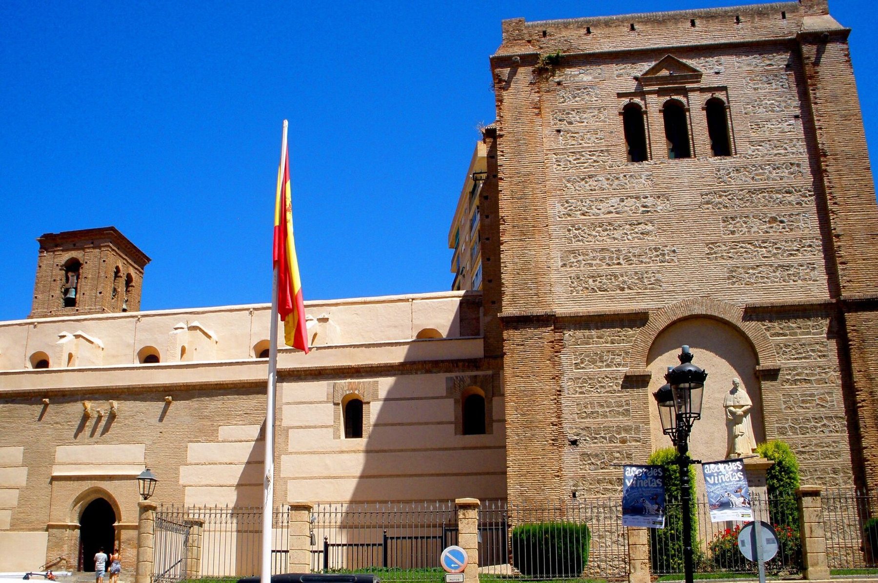
- Motril lay inland behind a wall with two gates, the Castell de Ferro gate and the Granada gate. Even the main church, the Iglesia Mayor de la Encarnación, was built like a fortress with massive walls and a tower like a castle keep.
- Nerja had cannons in the Torre de los Guardas where the Balcón de Europa is today, and all inhabitants were obliged to own weapons. See The Nerja Caves and Balcón de Europa.
The beaches where we swim today were empty back then. Only in the 19th century, once the danger had passed, did people really move down to the water.
The chain of watchtowers
The Moors already had watchtowers on the coast. After 1492 the Christian kings kept building, and especially under Philip II in the 16th century towers were placed along the whole coast, so that each tower could see the next. The towers are called torres vigía (watchtowers), atalayas or torres almenaras – from the Arabic word for a place where a fire is lit.
Smoke by day, fire by night
Each tower was manned by two or three torreros, watchmen. According to the Junta de Andalucía's heritage guide, they reported enemy ships with smoke signals by day (ahumadas) and fire by night. The next tower repeated the signal, and in this way the alarm ran along the coast and up to the towns much faster than a rider could carry it. Mounted guards patrolled the beach between the towers, and the townspeople could be called out to defend them.
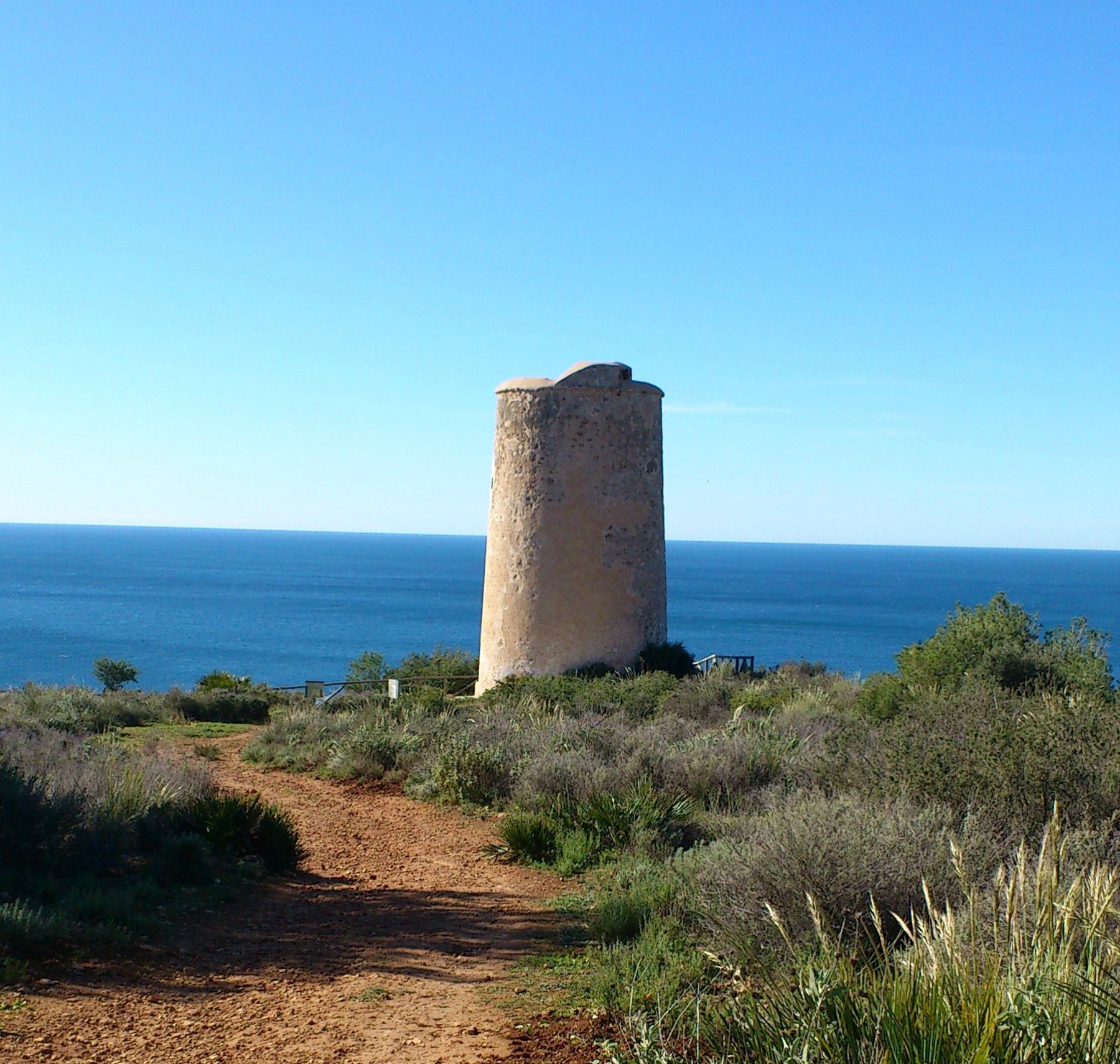
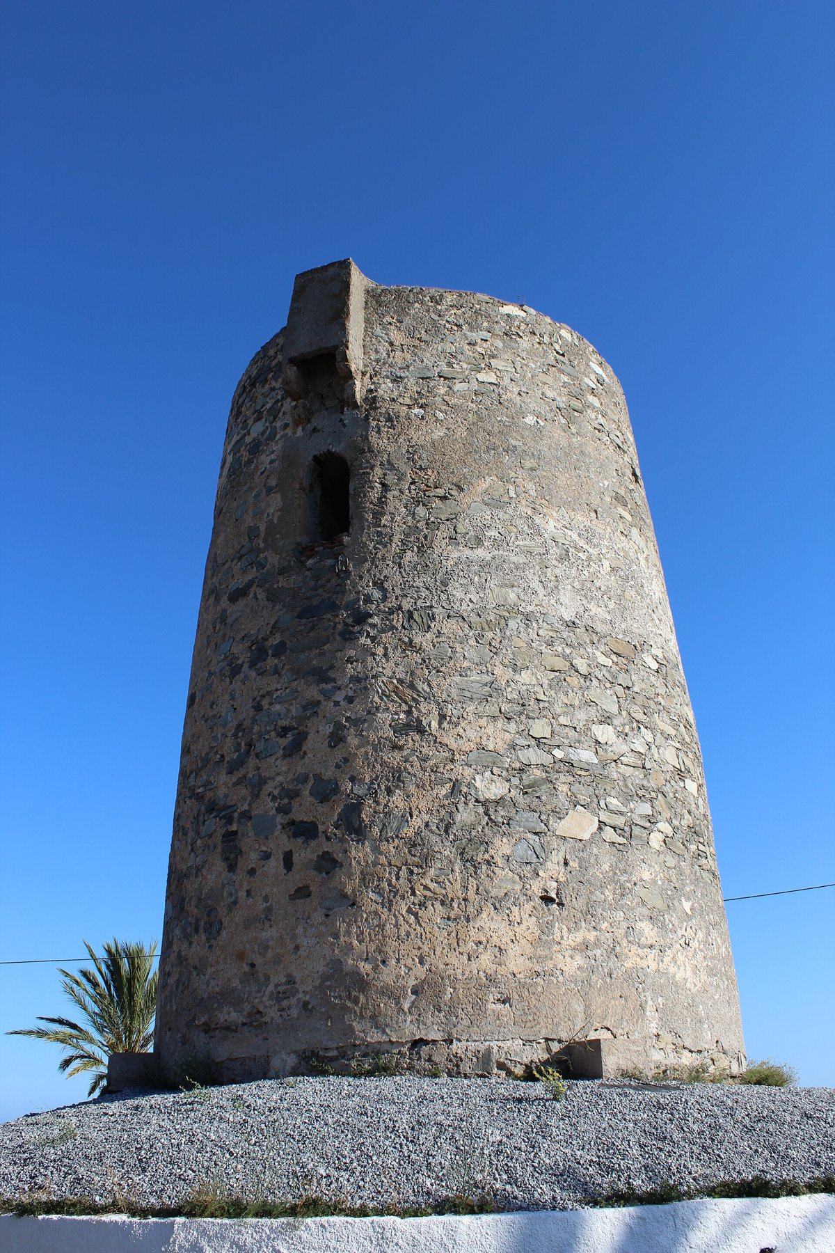
Most of the towers look alike: round and slightly conical, 10–12 metres high, built of natural stone. The lower part is solid. The door is 5–7 metres up, and you got in by a ladder that the watchmen pulled up after them. Above the door is a small projection, a matacán, from which stones could be dropped or shots fired down on attackers. Inside there was a single room with a fireplace, and at the top a flat roof terrace where the beacon fire was lit.
Carlos III and the big forts
In 1764 King Carlos III drew up a new plan for defending the coast of the old Kingdom of Granada. Old towers were repaired, and new, larger forts with cannon – baterías – were built at the bays where the pirates liked to land. From this period come Castillo de La Herradura (1771), Torre del Diablo (c. 1766), Torreón de Taramay and Fuerte de Carchuna.
When the danger had passed
In 1816 an Anglo-Dutch fleet bombarded Algiers, and in 1830 France conquered the city. That was the end of the pirates' era. The towers lost their purpose, but many were taken over by the Carabineros, the customs guards set up in 1829 to catch smugglers – read more in The smugglers on the coast. Today all the towers are protected as Bien de Interés Cultural.
The shipwreck at La Herradura in 1562
The greatest disaster on our coast in the age of the pirates was caused not by pirates but by the weather. On the morning of 19 October 1562 a Spanish fleet of 28 galleys under Juan de Mendoza sought shelter in the bay at La Herradura. It was on its way from Málaga to the Spanish towns of Oran and Mers-el-Kébir in Algeria, which were threatened by Algiers. A violent storm from the south-west hurled the galleys against the rocks at Punta de la Mona. 25 ships sank and around 5,000 people drowned, Mendoza among them. Only three galleys escaped. Cervantes mentions the disaster in Don Quixote. The story is told in the Museo 1562 at Castillo de La Herradura – see also the sea at La Herradura.
Legends and names
There are also stories about the towers that are not history:
- According to a local legend, Torre de la Rijana is named after two Moorish princesses, Harra and Hanna. It is a legend – we have found nothing to confirm it.
- Torre del Diablo, "the Devil's Tower", is also called Torre de las Golondrinas ("the Swallows' Tower") and Torre de la Cabria. We have not been able to find out why it got its devilish name.
- For pirate treasure on the coast, see Cueva del Tesoro – the cave east of Málaga where legend says a treasure lies hidden.
Timeline
| Year | What happened |
|---|---|
| 14th century | The Moors (the Nasrids) build watchtowers on the coast, including Torre del Granizo in Velilla and Torre del Cambrón |
| 1489 | Almuñécar and Salobreña surrender to the Catholic Monarchs |
| 1492 | Granada falls. Many Muslims flee to North Africa |
| 1516 | The Barbarossa brothers seize power in Algiers |
| 1526 | Almuñécar is granted its coat of arms (6 October). La Herradura is deserted for fear of corsairs |
| 1560 | Corsairs land at Castell de Ferro |
| 1562 | 25 Spanish galleys are wrecked at La Herradura (19 October) |
| 1567 | An inspection mentions a watchtower on Punta de la Mona |
| 1568–1571 | The Morisco revolt. Turks and Berbers fight on the rebels' side |
| 1575–1580 | Cervantes is a captive in Algiers and is ransomed by the Trinitarians |
| 16th/17th century | Most of the coast's round watchtowers are built, including Torre de Cerro Gordo and Torre de Maro |
| 1620 | Motril beats off a corsair attack |
| 1764 | Carlos III's plan for coastal defence. New forts and towers |
| 1771 | The cannon fort Castillo de La Herradura is completed |
| 1816 and 1830 | Algiers is bombarded and conquered by France. The age of the pirates is over |
| 1829 | The Carabineros are founded and take over many of the towers |
| 1990s | The tower on Punta de la Mona becomes a lighthouse |
| 2021 | Museo 1562 opens in Castillo de La Herradura |
| 5 February 2026 | The remains of Torre del Río de la Miel near Maro fall into the sea during a storm |
What you can see today: the towers from west to east
Here are the towers and forts that still stand today, which you can see from the road or walk up to. Distances are driving distances from Playa Tropical. You cannot go inside the towers – the doors are high up, and several stand on private land.
Torre de Maro – Nerja (28 km, 32 min.)
A well-preserved, 11-metre-high 16th-century tower on a rocky plateau east of the village of Maro, in the Acantilados de Maro-Cerro Gordo nature park. There are views along the coast in both directions. Park in Maro and follow the path – according to the EsNerja guide it takes about 10 minutes. A little further east, Torre del Río de la Miel stood on the edge of a cliff above Las Alberquillas beach. The sea had been eating away at it for decades, and on 5 February 2026 the last remains collapsed during a storm.

East of Maro stand Torre del Pino (on private land) and Torre Caleta on the cliffs above Cantarriján beach. You can see Torre Caleta from Cerro Gordo and even from the Balcón de Europa in Nerja.
Torre de Cerro Gordo – La Herradura (13 km, 20 min.)
The best tower to walk to. It stands at the tip of the Punta de Cerro Gordo headland, which closes off La Herradura bay to the west. It is 10.5 metres high, built in the late 16th or early 17th century on the site of an older Moorish tower. It was meant to protect the bay and Cantarriján beach, and in the 19th century the Carabineros used it as a lookout post. According to the Junta de Andalucía, from the tower you can see all the way from Salobreña to Torrox-Costa.
The Junta de Andalucía's waymarked trail Sendero Torre de Cerro Gordo starts at the Mirador de Cerro Gordo viewpoint. It is a circular walk of 2 km, about 40 minutes, moderate. The path goes down past the tower, on down over rougher ground with views over the bay, and back up through a pine wood. The height difference is about 150 metres. Look out for Spanish ibex (cabra montés) – they live on the cliffs. If you don't want to do the whole walk, just go down to the tower and come back the same way.


Punta de la Mona and Castillo de La Herradura (10 km, 16–18 min.)
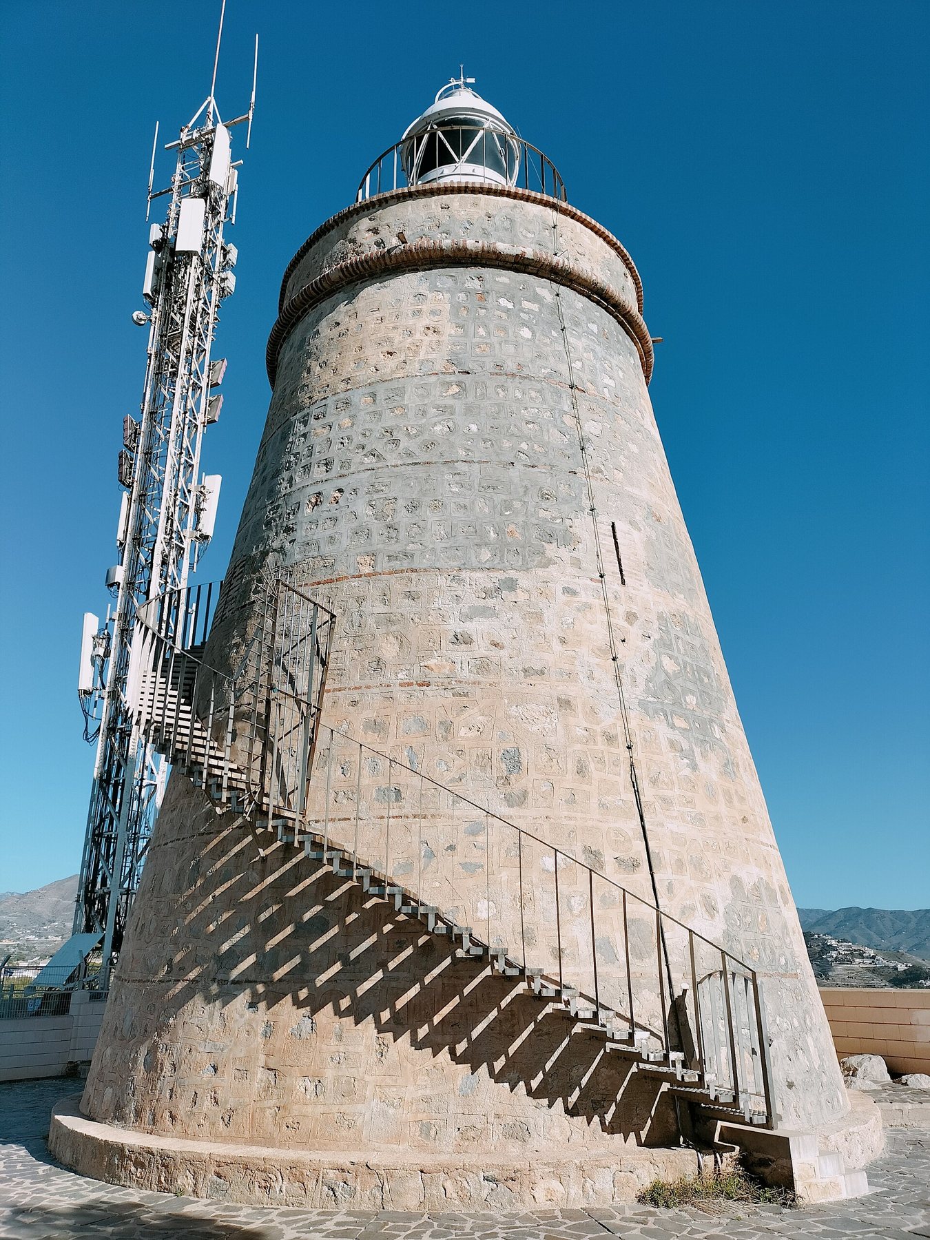
As early as 1567 there was a watchtower, "de La Rábita", on the headland east of La Herradura. The tower is of Moorish origin and was rebuilt under Carlos III's plan in 1767–1773. It had up to three watchmen, but no cannon. In the 1990s it was converted into the Faro de Punta de la Mona lighthouse, with a lantern and an outside staircase (sources say 1990 or 1992). OpenStreetMap shows car parks in the Punta de la Mona development close to the lighthouse.
Castillo de La Herradura, down on the seafront promenade, is not a medieval castle but a cannon fort for four guns, designed by the engineer José Crame in 1765 and completed in 1771. It was meant to stop pirates landing in the bay and to protect farmers and fishermen. Later the Carabineros, and finally the Guardia Civil, were based here until 2002. The town council restored the fort in 2007–2011, and in 2021 Museo 1562 La Furia del Mar opened, about the shipwreck of 1562. According to the Almuñécar tourist office's list from November 2025, it is open Wednesday–Sunday 10–14 and 16–19. We have not been able to confirm the admission price – ask at the tourist office.

Torre de Velilla – right next to Playa Tropical (under 1 km)
The nearest tower stands only about 600 metres from Playa Tropical as the crow flies, on the hill behind the western end of Velilla beach, among the villas on Calle Torrepinos. It is 12 metres high and still has its full height, with the door 7 metres up and a small projection above it. There is a railing around it and a view over the sea. We have not found a reliable date for when it was built. You can walk there in about 15 minutes, but the last stretch is up steep residential streets.
Torre del Granizo and Torreón de Taramay – Velilla-Taramay (2 km, 5 min.)
Two towers stand at the eastern end of Velilla. Torre del Granizo is a square Moorish tower from the 14th century, tucked away among the houses on the hill, with an information sign. Down by Playa del Tesorillo beach stands Torreón de Taramay, a horseshoe-shaped fort from after 1764 for two cannon. According to Wikipedia, the British took the cannon with them during the war against Napoleon. The fort is privately owned and used as a holiday home, so you see it from the beach and the promenade. There are beach bars at Playa del Tesorillo.

Torre de Enmedio and Torre del Diablo – Playa de Cabria (7 km, 15 min.)
On the Las Golondrinas rock above Playa de Cabria beach, east of Almuñécar, two towers stand side by side: the remains of the medieval Torre de Enmedio and the newer Torre del Diablo, built around 1766 to replace it. Torre del Diablo is 10.5 metres high and was manned by a corporal and two watchmen. From 1839 the Carabineros lived in it. You can see both towers from the N-340. OpenStreetMap shows paths up from the development above, but the last part is steep, and we have not walked it ourselves.

Torre del Cambrón – Salobreña (8 km, 14 min.)
A slender Moorish tower, only 3.9 metres in diameter and 10.5 metres high. It was raised by about 2 metres in the 16th century. From the tower you could see both Velilla and the whole Guadalfeo valley. Today it stands in the garden of Hotel Salobreña (in OpenStreetMap: Hotel Salobreña Suites) on the N-340, and you can see the top of it from the road and from the hotel car park. We don't know whether non-guests may walk into the garden – ask at reception. Afterwards you can drive on to the castle in Salobreña.
Fuerte de Carchuna – Motril (30 km, 32 min.)
A cannon fort from the time of Carlos III, built around 1777 or 1783 (the sources disagree) right by Playa de Carchuna beach. It has the same shape as the fort in La Herradura. During the Civil War, Franco's side used the fort as a prison, and in May 1938 a Republican special unit freed about 300 prisoners from here. You can see the fort from outside. We have not been able to confirm what it is used for inside today, or whether it is open. A little further east, Torre del Llano and Torre del Zambullón stand near Calahonda.

Torre de la Rijana and Castell de Ferro (33–37 km, 35–40 min.)
Torre de la Rijana stands on a rock between two small coves, La Rijana and La Rijanilla, right by the N-340. The rock was already fortified in the time of the Caliphate (10th–11th centuries), and the tower dates from the late 16th or early 17th century, built on top of older walls. Today it is a small, unstable ruin, only about 3.5 metres high. The beach became known after the film Al sur de Granada (2003). According to OpenStreetMap there is parking by the road and a beach bar. Don't go right out onto the rock by the ruin – it is fragile, and the edge is steep.
A couple of kilometres further on lies Castell de Ferro, with the remains of a Moorish castle on the hill above the town. According to Spanish Wikipedia, the town was almost deserted in the age of the pirates. Around Castell de Ferro several towers stand close together: Torre de Cambriles, Torre de la Estancia and Torre del Zambullón.


The drive: the towers along the N-340
The old coast road, the N-340, hugs the coast, while the A-7 motorway runs through tunnels further up. Take the old road and you will see the towers. The whole stretch from Maro to Castell de Ferro is about 70 km and takes about 1½ hours without stops – with stops and walks it is a full day. We suggest splitting it in two:
| Trip | Stop | Approx. length |
|---|---|---|
| Westwards (half day) | Torre de Velilla – Castillo de La Herradura and Museo 1562 – Mirador and Torre de Cerro Gordo (walk) – Torre de Maro. Home on the A-7 | About 60 km in total |
| Eastwards (half day) | Torreón de Taramay – Torre del Diablo (from the road) – Torre del Cambrón – Salobreña – Fuerte de Carchuna – Torre de la Rijana and lunch by the beach – home | About 70 km in total |
The N-340 is narrow and winding at Cerro Gordo and between Calahonda and Castell de Ferro. There are few places to pull in, so stop only at car parks and viewpoints. Watch your speed – see speed checks.
How to get there
By car
- Torre de Cerro Gordo: Take the N-340 towards La Herradura and on towards Nerja. Take the exit for Cerro Gordo and follow the road up to the Mirador de Cerro Gordo. About 13 km, 20 minutes. There is a car park at the viewpoint (free according to a German castle guide), and the path starts at the information board.
- Torre de Maro: About 28 km, 32 minutes on the A-7 or N-340 to Maro. Park by the village. In summer there are few spaces, so come early.
- Torre de la Rijana: About 33 km, 35 minutes on the A-7 and N-340 towards Castell de Ferro. Parking by the road above the beach.
The buttons below the map at the bottom open the routes from Playa Tropical directly in Google Maps – the drive straight to Cerro Gordo, the tower routes west and east, and the walks. See also parking and car hire.
On foot and by bus
You can walk to Torre de Velilla and Torreón de Taramay from Playa Tropical. ALSA's coastal buses run along the N-340, but they don't stop at the towers, so for the rest a car is easiest. Read more under buses.
Practical info
Toilets
- Playa del Tesorillo (Taramay): OpenStreetMap shows a toilet at the beach.
- Maro: OpenStreetMap shows a toilet at the car park in the village.
- Cerro Gordo, Torre del Diablo, Torre del Cambrón and Rijana: There are no public toilets that we have been able to find. Use a restaurant or beach bar – buy a coffee and it's fine.
Food
- Mirador de Cerro Gordo: There is a restaurant at the viewpoint. OpenStreetMap gives the opening hours as Saturday–Sunday 13–22, but we have not been able to confirm this.
- La Herradura: The promenade by Castillo de La Herradura is full of restaurants and beach bars.
- Playa del Tesorillo: several beach bars (chiringuitos) right by Torreón de Taramay.
- La Rijana: According to OpenStreetMap there is a beach bar on the beach. We don't know whether it is open outside the summer.
We have not checked prices. More about the local food: food traditions.
Accessibility
Torre de Velilla, Torreón de Taramay, Torre del Cambrón and Fuerte de Carchuna can be seen from the road or promenade without walking over rough ground. Castillo de La Herradura is on the flat seafront promenade. Torre de Cerro Gordo and Torre de Maro require a short walk on gravel and stony paths without shade – not suitable for wheelchairs or rollators. At Torre del Diablo and Rijana the paths are steep.
Maps and routes
Red star = Playa Tropical. Click on a point for the name and distance. Map data © OpenStreetMap.
Open the route in Google Maps
- Drive from Playa Tropical to Torre de Cerro GordoAbout 13 km, 20 min on the N-340. Park at the Mirador de Cerro Gordo, where the path to the tower starts.
- The towers on the way to Cerro GordoTorre de Velilla and Castillo de La Herradura with Museo 1562 on the way to Cerro Gordo – about 15 km on the N-340.
- The tower route west to MaroVelilla, La Herradura, Cerro Gordo and Torre de Maro on the old N-340 – home on the A-7. About 60 km.
- The tower route east on the N-340Taramay, Torre del Diablo, Torre del Cambrón, Fuerte de Carchuna and Torre de la Rijana – and home. About 70 km.
- Walk from Playa Tropical to Torre de VelillaUnder 1 km, approx. 15 min. The last stretch is up steep residential roads.
- Walk from the car park to Torre de Cerro GordoThe Junta de Andalucía's trail: a 2 km circular walk, about 40 min, moderate. Stony path without shade.
The routes start at Playa Tropical – walks on site and trips on the other side of the Strait start at the route's first point. On your mobile they open directly in the Google Maps app, ready for navigation.
Good advice
- Start at the front door. Walk the 15 minutes up to Torre de Velilla – then you have seen a real watchtower before you even get in the car.
- Bring good shoes and water. The paths at Cerro Gordo and Maro are stone and gravel, and there is no shade.
- Come early in summer. At Maro and Cerro Gordo the car parks fill up quickly, and the midday heat is harsh on the cliffs.
- Keep away from the edge. The cliffs at Rijana, Cerro Gordo and Torre del Diablo are steep, and the ruins are fragile. Do not climb the towers.
- Look for the next tower. Stand by a tower and look along the coast – often you can see the next one. Then you understand how the signals travelled.
- Combine it with the museum. Museo 1562 in La Herradura gives you the background – check the opening hours with the tourist office before you go.
- Respect private property. Torreón de Taramay and Torre del Pino are private, and Torre del Cambrón stands in a hotel garden.
The towers are protected monuments. You may not climb them, take stones away or light fires – nor on the dry slopes around them, where the fire risk is high in summer. In an emergency: call 112.
Sources
- Wikipedia (es): Torres de vigilancia costera en España (Charles V, Philip II, the list of towers in Granada province)
- Wikipedia (es): Torre de Cerro Gordo, Torre de Velilla, Torreón de Taramay, Torre del Granizo, Torre del Diablo, Torre del Cambrón (all derived from the Junta de Andalucía's Guía Digital del Patrimonio Cultural de Andalucía)
- Wikipedia (es): Torre de Maro, Torre Caleta, Torre del Pino and Torre del Río de la Miel
- Hispania Nostra, Lista Roja: Torre de la Miel and MonumentalNet (the collapse on 5 February 2026)
- Wikipedia (es): Castillo de La Herradura and Faro de Punta de la Mona
- Wikipedia (es): Fuerte de Carchuna
- Wikipedia (es): Gualchos and Castell de Ferro (Torre de la Rijana, the legend of Harra and Hanna)
- Junta de Andalucía: Sendero Torre de Cerro Gordo (2 km, 40 min., moderate)
- Wikipedia (es): Desastre naval de La Herradura and La Herradura (Granada)
- Wikipedia (es): Almuñécar and Euro Weekly News 29-09-2026: 500 years of Almuñécar's coat of arms
- Wikipedia (es): Motril (the town wall, the church and the attack in 1620) and Nerja (Torre de los Guardas)
- Wikipedia (es): Piratería berberisca and No hay moros en la costa
- ¡Ah de la nave! (Dialnet) (the landing at Castell de Ferro in 1560)
- Wikipedia (en): Miguel de Cervantes (his captivity in Algiers 1575–1580)
- EsNerja: Maro (the walk to Torre de Maro)
- Driving distances: OSRM/OpenStreetMap
- Coordinates: OpenStreetMap contributors (ODbL)


