

← All stories about pirates and smugglers
Why smuggle here of all places?
The answer is tobacco. In Spain tobacco was a state monopoly: only the state could sell it, and the duty was high. According to Andalupedia, from the time of Philip IV in the 17th century tobacco was already "the most open and sought-after" contraband, and it remained so for a long time. Other goods were silk cloth, cocoa, spices and, in wartime, weapons and horses. Rincones de Granada also mentions English cotton cloth and soap.
The goods came from Gibraltar. The British captured the Rock in 1704, and with the Peace of Utrecht in 1713 it became British. Andalupedia calls it the start of "a furious smuggling trade". Gibraltar was a free port, and here you could buy tobacco without Spanish duty. How much was involved was spelt out by the British politician Sir David Wedderburn in the House of Commons on 16 June 1871: over three years about 30,000 hundredweight of American tobacco had come into Gibraltar, and over 29,000 of them – around 1,500 tonnes – had been sent on again "and doubtless found their way into Spain".


From Gibraltar the goods went east along the coast by boat. The Costa Tropical had what the smugglers needed: steep cliffs, many small coves that could not be seen from land, and mountains right behind with paths inland to Granada and Málaga. Rincones de Granada describes the cliffs at Maro-Cerro Gordo and the coast below the Contraviesa mountains east of Motril as a landscape of "countless caves and coves where the smugglers unloaded at night".
The smugglers' coves
Which coves were used, and when? It is hard to say precisely. Smugglers kept no accounts, and we have not found sources naming landings at our coves in particular. But the landscape speaks for itself – and this is where the authorities posted their guards:
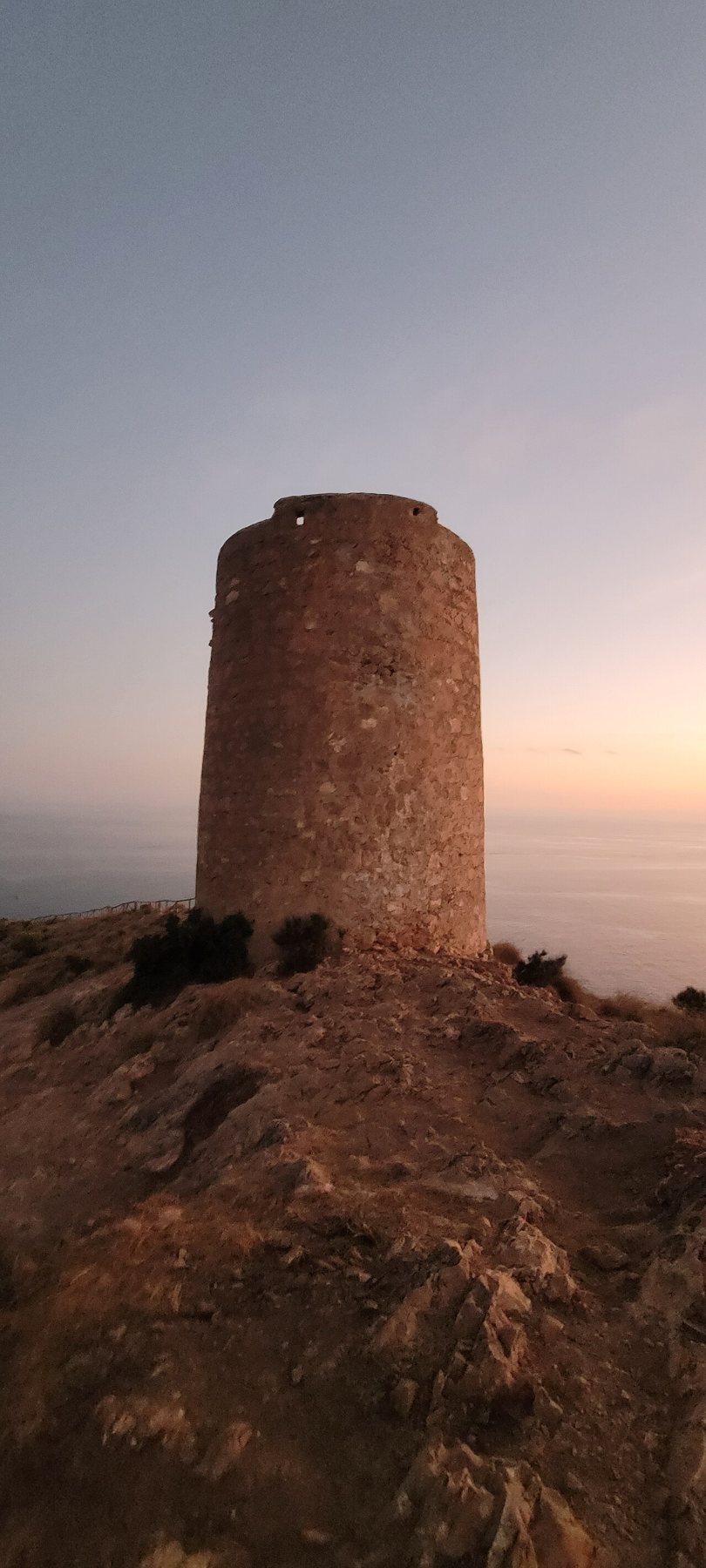
- Cantarriján and El Cañuelo lie at the bottom of deep ravines between Cerro Gordo and Maro. You can see them from the sea, but hardly from land. Above the coves stand Torre Caleta and Torre de Cerro Gordo – the latter became the carabineros' lookout post.
- Maro: The cliffs east of Nerja are full of small inlets that can only be reached on foot down steep paths or from the water.
- La Herradura: In the 16th century the horseshoe bay was a well-known hiding place for pirates. Later it got the coast's most important Carabineros barracks.
- Calaiza: A small stony cove below the cliffs near Almuñécar, which can still only be reached by a steep path or from the sea.


The coast is still used by smugglers. In December 2018 a fast inflatable with hashish landed at Calaiza itself, after radar had spotted it off Almuñécar (The Seaside Gazette). You can read about smuggling today in Smuggling in recent times.
Over the mountains with donkeys and mules
Once the goods were ashore, they had to go on inland, where the buyers were. The route went over the mountains behind the coast: the Sierra de Almijara and Sierra Tejeda, which rise right behind Nerja and Almuñécar – Sierra Tejeda to just over 2,000 metres. There were no roads for vehicles. Everything was carried on the backs of mules and donkeys by arrieros, the muleteers, who also carried the legal goods between the coast and the towns.

A report by Colonel José de Alabes dated 16 April 1782 shows what a smugglers' caravan could look like. The report concerns a route further inland, between Córdoba and Granada, through Lucena, Rute, Iznájar and Montefrío. Here the soldiers seized 15 horses, 80 pounds of Brazilian tobacco, 14 rifles, three blunderbusses and eight pistols (Andalupedia). In other words, the smugglers were armed.
Traces of the old traffic over the mountains can still be found. The Junta de Andalucía describes the ruin of Venta de López, on the path between Játar and Puerto de Cómpeta, as an old inn for shepherds, muleteers and traders. We have not been able to find any record of which paths were the smugglers' own – the same mule tracks were used by everyone.


Romance and reality
In the 19th century the Andalusian smuggler became a popular figure in European art and literature, with a fine costume, a rifle and a donkey loaded with tobacco. The most famous is probably the smuggling gang in Bizet's opera Carmen (1875). Reality was greyer. Rincones de Granada writes that smuggling often had the tacit support of the poor local population. But it was dangerous: both sides were armed.


The customs guards: from coastal companies to Carabineros
For a long time the Crown tried to stop the smuggling. Before the Carabineros, the Compañías de Infantería Fija de la costa de Granada – permanent coastal companies – guarded over 400 nautical miles of coast from Tarifa to Almería, with garrisons in places such as Vélez, Almuñécar and Motril. According to Andalupedia they were "a firm bulwark" against the smugglers, but they could never wipe them out: the soldiers were poorly paid and poorly armed, and they were recruited locally. There were also customs guards, resguardos, who patrolled the coasts and fields.
On 9 March 1829 King Ferdinand VII established by royal decree the Real Cuerpo de Carabineros de Costas y Fronteras – "the Royal Corps of Carabineers for Coasts and Borders". The corps was organised by Field Marshal José Ramón Rodil and came under the Ministry of Finance, not the army. Its task was to guard the coasts and borders and to fight smuggling and tax fraud. In 1936 the corps numbered 16,096 men.
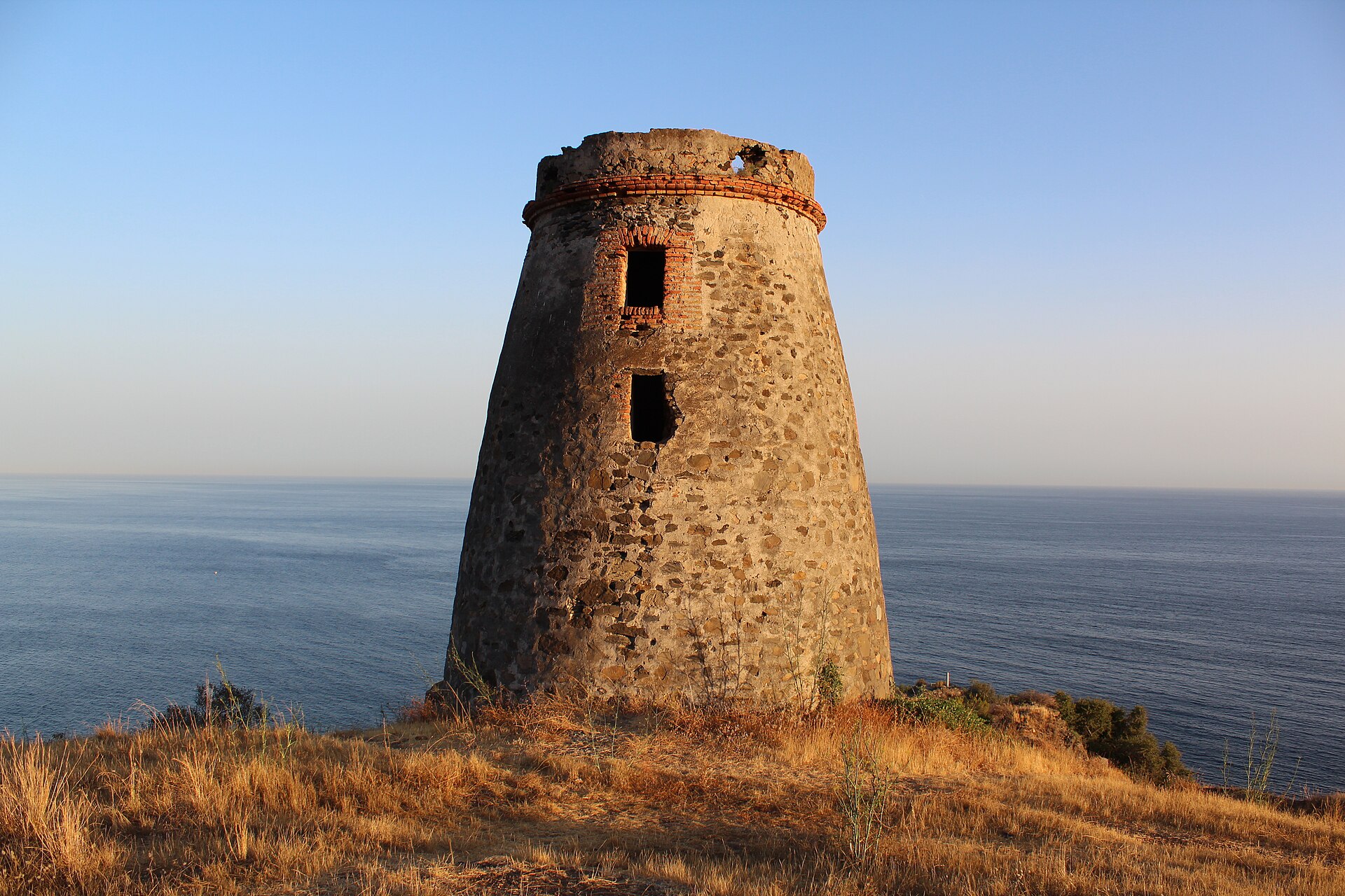
The Carabineros moved in all along the coast. They used the old watchtowers left over from the age of the pirates: Torre del Diablo east of Almuñécar had carabineros from 1839, and Torre de Cerro Gordo became their lookout post in the 19th century. The cannon fort Castillo de La Herradura became their barracks. Elsewhere new guardhouses, casas-cuartel, were built down by the beach.
Rincones de Granada describes life at the stations: rectangular houses of one or two storeys with thick walls against the salt. The guards lived there with their families, often far from the nearest village, and some married local women. Every night they "walked the path" (hacer la vereda): they patrolled their stretch of coast in darkness and wind until they met the guard from the next station. The site mentions Castell de Ferro and Calahonda as places where the carabineros lived closely with the village, and the barracks at La Mamola as a classic example. We have not been able to confirm whether those buildings still stand today.
The Civil War and the Guardia Civil
When the Civil War broke out in 1936, most of the Carabineros sided with the lawful Republican government. According to Spanish Wikipedia, about a third, 5,000–6,000 men, went over to the rebels. After Franco's victory the corps was abolished by the law of 15 March 1940. Its tasks and many of its men were transferred to the Guardia Civil, which had been founded in 1844 to keep law and order in the countryside. From then on the Guardia Civil guarded the coast – also in the years after the war, when poverty and rationing made the black market, estraperlo, part of everyday life all over Spain. You can read about the fight against the guerrillas in the mountains in those years in The guerrillas in the Almijara, and about the older highwaymen in The bandits in the mountains.
The Guardia Civil were based in Castillo de La Herradura until 2002 (another source says 2003). Many of the old guardhouses fell into ruin. At the mouth of the Río Torrox, about 25 km west of Playa Tropical as the crow flies, the ruin of a Carabineros barracks stood on the edge of the cliff. It was about to collapse, and in 2017 the Spanish Ministry for the Environment had it demolished for about 50,000 € (≈ 373,000 kr.) and restored the cliff. At the same time, invasive plants that threatened the rare coastal plant Limonium malacitanum were removed.
Timeline
| Year | What happened |
|---|---|
| 17th century | Under Philip IV tobacco becomes the main contraband. Tobacco is a state monopoly in Spain |
| 1704 / 1713 | Gibraltar is captured by the British and becomes British with the Peace of Utrecht – the free port becomes the smugglers' warehouse |
| Before 1829 | Permanent coastal companies guard the coast from Tarifa to Almería, including at Almuñécar and Motril |
| 1771 | The cannon fort Castillo de La Herradura is completed (against the pirates) |
| 16 April 1782 | Colonel Alabes seizes horses, tobacco and weapons from an armed smugglers' caravan between Córdoba and Granada |
| 9 March 1829 | Ferdinand VII establishes the Carabineros de Costas y Fronteras |
| 1839 | The Carabineros move into Torre del Diablo near Almuñécar |
| 1844 | The Guardia Civil is founded |
| 16 June 1871 | In the British House of Commons it is stated that about 1,500 tonnes of tobacco went on from Gibraltar to Spain over three years |
| 1875 | Bizet's opera Carmen, with its smuggling gang, has its premiere |
| 1936 | The Carabineros number 16,096 men. Most side with the Republic in the Civil War |
| 15 March 1940 | The Carabineros are abolished and absorbed into the Guardia Civil |
| 2002 | The Guardia Civil leaves Castillo de La Herradura |
| 2017 | The ruin of the carabinero barracks at Río Torrox is demolished |
| 2021 | The first section of the Paseo de los Carabineros in Nerja is restored. Museo 1562 opens in Castillo de La Herradura |
What you can see today
Castillo de La Herradura – the carabineros' barracks (9.5 km, 16 min.)
The low stone fort stands in the middle of the seafront promenade in La Herradura. It was designed in 1765 and completed in 1771 as a cannon fort against the pirates, later served as barracks for the Carabineros and finally for the Guardia Civil until 2002. The town council restored it in 2007–2011, and today it houses Museo 1562 La Furia del Mar about the wreck of the fleet in the bay in 1562 – read more in Pirates and watchtowers. According to the Almuñécar tourist office's list from November 2025, it is open Wednesday–Sunday 10–14 and 16–19. We have not been able to confirm the current price – check with the tourist office.


Torre de Cerro Gordo – the carabineros' lookout post (13 km, 20 min.)
The tower from around 1600 stands at the tip of the headland west of La Herradura. By the 19th century it had lost its role against the pirates, and the Carabineros used it as a lookout post. From here you can look down into both La Herradura bay and the bay at Cantarriján. The Junta de Andalucía's waymarked trail starts at the Mirador de Cerro Gordo: a 2 km circular walk, about 40 minutes, moderate, with about 150 metres of height difference. If you don't want to do the whole walk, just go down to the tower and come back the same way.
The bay at Cantarriján (13 km, 20 min.)
The beach just west of Cerro Gordo is today a peaceful naturist beach with two beach restaurants. In summer (2026: 15 June–10 September) the road is closed to cars, and a shuttle bus runs down from the car parks on the N-340. The rest of the year you can drive down or walk the roughly 1.5 km. Read more in Maro-Cerro Gordo.
Torre del Diablo – Almuñécar
The tower on the rock above Playa de Cabria beach, east of Almuñécar, can be seen from the old coast road, the N-340. It was built around 1766, and from 1839 carabineros lived there. There is no waymarked path up, and the last part is steep – enjoy it from the road or the beach.
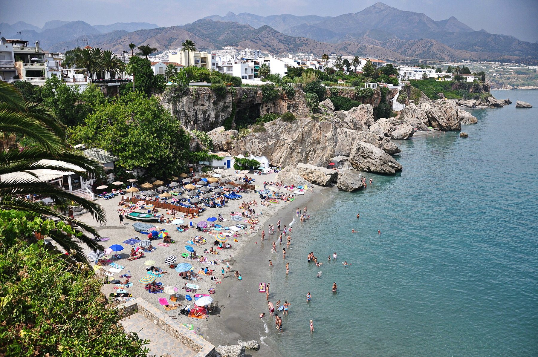
Paseo de los Carabineros – Nerja (30 km, about 30 min.)
In the middle of Nerja, below the Balcón de Europa viewpoint, lies the small beach of Calahonda with fishing boats and rocks. From here the Paseo de los Carabineros ran east beneath the cliffs along the sea towards Burriana beach. According to The Seaside Gazette it was opened in the mid-1990s, but closed after rockfalls around 2002. The first section from Calahonda was restored for about 314,000 € (≈ 2,342,440 kr.), paid for by Málaga province, and was finished in June 2021, with new steps down to the beach and two viewpoints. We have not been able to confirm whether the rest is open today – follow the signs and never go past a barrier. The sources don't say why the path has this name, but it recalls the guards who once patrolled the coast here.
Why not combine the trip with the Nerja caves or Frigiliana, where you can see the mountains the mule tracks crossed.
How to get there from Playa Tropical
- Castillo de La Herradura: Drive west on the N-340 to La Herradura and down towards the seafront promenade (Paseo Andrés Segovia). 9.5 km, about 16 min. Parking in the streets behind the promenade – in summer it can be difficult.
- Torre de Cerro Gordo and Cantarriján: Continue on the N-340 past La Herradura towards Nerja. The Mirador de Cerro Gordo is right by the road, with a car park at the viewpoint and the restaurant. A little further on are the car parks for Cantarriján. 13 km, about 20 min.
- Nerja and Paseo de los Carabineros: On the A-7 or N-340 to Nerja, about 30 km and 30 min. Easiest is the underground Parking Balcón de Europa beneath Plaza de España. From there it is a few minutes' walk to the Balcón de Europa and the steps down to Calahonda. Street parking is almost impossible.
- By bus: ALSA's coastal buses between Almuñécar and Nerja stop in La Herradura and in Nerja – see buses. For Cerro Gordo you need a car or taxi.
The buttons below the map at the bottom open the routes from Playa Tropical directly in Google Maps – the drive straight to the barracks in La Herradura, the smugglers' coast to the west, and the walks. See also parking, car hire and speed checks – the N-340 at Cerro Gordo is narrow and winding.
Practical info
Toilets
- La Herradura: OpenStreetMap shows a free public toilet on the promenade about 200 m from Castillo de La Herradura.
- Nerja, Calahonda: OpenStreetMap shows free public toilets down by Calahonda beach.
- Cerro Gordo and Cantarriján: No public toilets that we have been able to find. Use the restaurant at the viewpoint or the beach restaurants – as a customer.
Food
- La Herradura: The promenade around the fort is full of restaurants and beach bars. Try espetos – sardines grilled on skewers over an open fire. Read more about the food traditions.
- Cerro Gordo: The restaurant at the Mirador de Cerro Gordo. We have not been able to confirm the opening hours.
- Cantarriján: Two beach restaurants in the first cove, including La Barraca with fish and seafood.
- Nerja: The streets around the Balcón de Europa and Plaza de España are full of tapas bars and restaurants.
On foot and accessibility
Castillo de La Herradura is on the flat promenade and easy to get to. The path to Torre de Cerro Gordo is stone and gravel, without shade – not suitable for wheelchairs or rollators. There are steps down to Calahonda in Nerja. Torre del Diablo is best seen from the road.
Maps and routes
Red star = Playa Tropical. Click on a point for the name and distance. Map data © OpenStreetMap.
Open the route in Google Maps
- Drive from Playa Tropical to Castillo de La Herradura9.5 km, about 16 min on the N-340. The carabineros' old barracks on the seafront promenade.
- The smugglers' coast to the westCastillo de La Herradura, Mirador de Cerro Gordo and the bay at Cantarriján – about 14 km on the N-340.
- Round trip: La Herradura, Cerro Gordo and NerjaThe barracks, the lookout post and the Paseo de los Carabineros in Nerja – and home on the A-7. About 60 km.
- Drive from Playa Tropical to Nerja and the Paseo de los CarabinerosAbout 30 km, 30 min. Park in the underground car park beneath Plaza de España.
- Walk from the car park to Torre de Cerro GordoThe Junta de Andalucía's trail: 2 km circular walk, about 40 min, moderate. No shade.
- Walk from the car park in Nerja to the Paseo de los CarabinerosUnder 1 km via the Balcón de Europa and the steps down to Calahonda.
- Drive to the view over Torre del DiabloA few minutes east on the N-340 – the tower can be seen from the road above Playa de Cabria.
The routes start at Playa Tropical – walks on site and trips on the other side of the Strait start at the route's first point. On your mobile they open directly in the Google Maps app, ready for navigation.
Good advice
- Start in La Herradura. The barracks and the museum give you the background – check the opening hours with the tourist office before you go.
- Bring good shoes and water. The paths at Cerro Gordo are stone and gravel, and there is no shade.
- Come early in summer. The car parks at Cerro Gordo, Cantarriján and in Nerja fill up quickly.
- Keep away from the edge. The cliffs are steep, and stones fall. Never go past a barrier on the Paseo de los Carabineros.
- Take the N-340. The old coast road goes past the towers and coves – the motorway runs through tunnels.
- Read on. Pirates and watchtowers tells why the towers were built, and The sea at La Herradura is about snorkelling and boating in the coves.
If you see something suspicious on the beach today – such as a boat unloading at night, or packages washed ashore – don't touch it, move away and call 112 or the Guardia Civil on 062.
Sources
- Wikipedia (es): Cuerpo de Carabineros (the decree of 9 March 1829, Rodil, 16,096 men in 1936, the Civil War, the law of 15 March 1940)
- Andalupedia: Contrabando (tobacco, Gibraltar 1704/1713, the coastal companies, the 1782 report, Guardia Civil 1844)
- Hansard, House of Commons 16 June 1871: Sir David Wedderburn on Gibraltar (the tobacco figures)
- Rincones de Granada: Real Cuerpo de Carabineros (life at the stations, Maro-Cerro Gordo, La Mamola – without source references)
- Wikipedia (es): Castillo de La Herradura, Torre de Cerro Gordo and Torre del Diablo
- MITECO: Demolition of the old carabinero barracks at Río Torrox (2017, 50,032 € (≈ 373,239 kr.))
- The Seaside Gazette 26-10-2020: Paseo de los Carabineros and Euro Weekly News 03-06-2021: the work at Calahonda is finished
- The Seaside Gazette 2018: Drugs bust on La Herradura beach (Calaiza)
- Junta de Andalucía: Sendero Torre de Cerro Gordo
- Coordinates: OpenStreetMap contributors (ODbL)
Krone amounts are converted at 1 € ≈ 7.46 kr. and rounded.


